


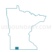
Wisconsin Twp. Voting District, Jackson County, Minnesota
About
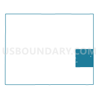
Outline

Summary
| Unique Area Identifier | 602656 |
| Name | Wisconsin Twp. Voting District |
| County | Jackson County |
| State | Minnesota |
| Area (square miles) | 35.47 |
| Land Area (square miles) | 35.47 |
| Water Area (square miles) | 0.00 |
| % of Land Area | 100.00 |
| % of Water Area | 0.00 |
| Latitude of the Internal Point | 43.63119780 |
| Longtitude of the Internal Point | -94.91430960 |
Maps

Graphs
Select a template below for downloading or customizing gragh for Wisconsin Twp. Voting District, Jackson County, Minnesota


Neighbors
Neighoring Voting District (by Name) Neighboring Voting District on the Map
- Alpha Voting District, Jackson County, MN
- Belmont Twp. Voting District, Jackson County, MN
- Des Moines Twp. Voting District, Jackson County, MN
- Elm Creek Twp. Voting District, Martin County, MN
- Enterprise Twp. Voting District, Jackson County, MN
- Jackson W-1 P-1, Jackson County, MN
- Jackson W-2 P-1, Jackson County, MN
- Jay Twp. Voting District, Martin County, MN
- Lake Fremont Twp. Voting District, Martin County, MN
- Middletown Twp. Voting District, Jackson County, MN
- Petersburg Twp. Voting District, Jackson County, MN
Top 10 Neighboring County Subdivision (by Population) Neighboring County Subdivision on the Map
- Jackson city, Jackson County, MN (3,299)
- Jay township, Martin County, MN (237)
- Wisconsin township, Jackson County, MN (233)
- Petersburg township, Jackson County, MN (232)
- Des Moines township, Jackson County, MN (232)
- Middletown township, Jackson County, MN (227)
- Belmont township, Jackson County, MN (218)
- Elm Creek township, Martin County, MN (188)
- Enterprise township, Jackson County, MN (187)
- Lake Fremont township, Martin County, MN (162)
Top 10 Neighboring Place (by Population) Neighboring Place on the Map
Top 10 Neighboring Unified School District (by Population) Neighboring Unified School District on the Map
- Jackson County Central School District, MN (7,797)
- Martin County West Public School District, MN (4,520)
Top 10 Neighboring State Legislative District Lower Chamber (by Population) Neighboring State Legislative District Lower Chamber on the Map
Top 10 Neighboring State Legislative District Upper Chamber (by Population) Neighboring State Legislative District Upper Chamber on the Map
Top 10 Neighboring 111th Congressional District (by Population) Neighboring 111th Congressional District on the Map
Top 10 Neighboring Census Tract (by Population) Neighboring Census Tract on the Map
- Census Tract 4804, Jackson County, MN (3,346)
- Census Tract 7902, Martin County, MN (2,587)
- Census Tract 7903, Martin County, MN (2,430)
- Census Tract 4801, Jackson County, MN (2,276)
- Census Tract 7904, Martin County, MN (1,939)